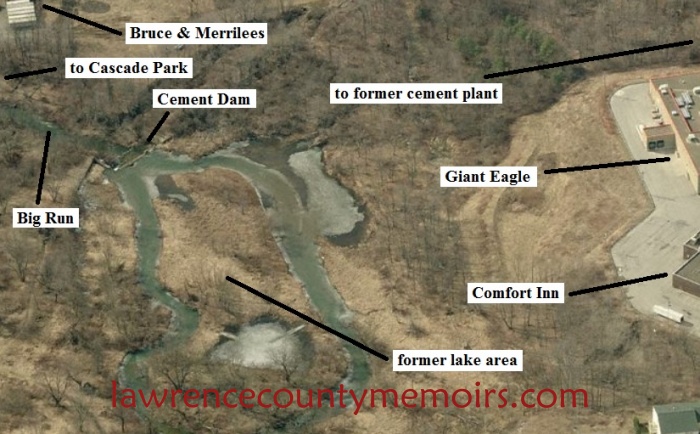
One easy and relatively secluded access route to Cement Dam was via a B&O railroad spur which split from yet another spur track a stone’s throw east of Cascade Park.
The Cement Dam tracks crossed Big Run on a trestle about 100’ west of the dam. Walking across that trestle was fear inducing. You usually had relatively little concern for trains because the engine rumble could be heard from a distance and trains rarely traveled more than 15 mph. But placing your feet on the crossties while viewing the trestle’s height over the rocks and swirling water of Big Run could make for some weak knees or sweaty palms.
Heading north, the Cement Dam spur track eventually crossed Butler Road (422) west of the Flowline plant (between Flowline and Rigotti’s plaza). From there, the tracks began curving northwest to cross North Cascade Street slightly north of its intersection with Grandview Avenue. (Current Google Maps shows Holly’s Hobbies as the business now occupying the building that was once the northern terminus of the Cement Dam railroad spur.) A gondola filled with metal shavings was a sign of the type of business that utilized the B&O there in the 60s.
If you traveled south on the Cement Dam Spur, its tracks intersected the east / west spur just east of Cascade Park. Westbound, that track ran beneath the Route 65 overpass and passed the southern edge of Cascade Park by the park’s mini-train tunnel. That route eventually joined more significant B&O routes near the Moravia Street Viaduct.
The eastbound leg of the east/west spur ran across Butler Road (422) then Old 422 and beyond Frew Mill Road. I was told that the eastbound track ended at the Fenati Brick, factory, but I never witnessed that myself.
This is actually on my father’s property. Him and I spent many of hours walking back there, sitting and watching the water and talking about life. He owns the small trailer park that sits on the same side as Giant Eagle. If you’d like pictures of what the dam looked like before and what the dam looks like today I’m sure my dad can find some old pictures around and I’d be more than willing to provide pictures of what it looks like today. My father’s side of the family has owned the property since they came to New castle from Italy and originally owned the property on both sides of the road. It was my Great grandfather that sold the other side so it was in our family for quite some time. I found that out through an ancestry search record. The first U.S. census they’re listed in, they have that listed as their address.


Comments
J Jessel #
One easy and relatively secluded access route to Cement Dam was via a B&O railroad spur which split from yet another spur track a stone’s throw east of Cascade Park.
The Cement Dam tracks crossed Big Run on a trestle about 100’ west of the dam. Walking across that trestle was fear inducing. You usually had relatively little concern for trains because the engine rumble could be heard from a distance and trains rarely traveled more than 15 mph. But placing your feet on the crossties while viewing the trestle’s height over the rocks and swirling water of Big Run could make for some weak knees or sweaty palms.
Heading north, the Cement Dam spur track eventually crossed Butler Road (422) west of the Flowline plant (between Flowline and Rigotti’s plaza). From there, the tracks began curving northwest to cross North Cascade Street slightly north of its intersection with Grandview Avenue. (Current Google Maps shows Holly’s Hobbies as the business now occupying the building that was once the northern terminus of the Cement Dam railroad spur.) A gondola filled with metal shavings was a sign of the type of business that utilized the B&O there in the 60s.
If you traveled south on the Cement Dam Spur, its tracks intersected the east / west spur just east of Cascade Park. Westbound, that track ran beneath the Route 65 overpass and passed the southern edge of Cascade Park by the park’s mini-train tunnel. That route eventually joined more significant B&O routes near the Moravia Street Viaduct.
The eastbound leg of the east/west spur ran across Butler Road (422) then Old 422 and beyond Frew Mill Road. I was told that the eastbound track ended at the Fenati Brick, factory, but I never witnessed that myself.
Leslie #
This is actually on my father’s property. Him and I spent many of hours walking back there, sitting and watching the water and talking about life. He owns the small trailer park that sits on the same side as Giant Eagle. If you’d like pictures of what the dam looked like before and what the dam looks like today I’m sure my dad can find some old pictures around and I’d be more than willing to provide pictures of what it looks like today. My father’s side of the family has owned the property since they came to New castle from Italy and originally owned the property on both sides of the road. It was my Great grandfather that sold the other side so it was in our family for quite some time. I found that out through an ancestry search record. The first U.S. census they’re listed in, they have that listed as their address.
Comment