


In 1869, two enterprising young men from Butler County, Pennsylvania, Russell H. Boggs (1844-1922) of Evans City and Henry Buhl, Jr. (1848-1927) of Zelienople, formed a partnership and opened up a small dry goods business, the Boggs & Buhl Department Store, on Federal Street in Allegheny City (now the North Side of Pittsburgh and next to PNC Park). The two men worked extremely hard and sold all sorts of items including suits, dresses, hats, furs, children’s clothing, and household items. Slowly but surely their business became a thriving success with its upscale store and a large mail order clientele. The Boggs & Buhl store soon expanded and became well-known throughout the Pittsburgh area for its unmatched customer service.
Boggs, a former traveling salesman, believed in expanding the local transportation network. Pittsburgh itself was served by a city-wide street car system, but there was no such service to reach the lucrative customers to the north of the city. Boggs envisioned an interurban railway as a solution to stay connected with his many customers and friends to the north. The line would provide daily passenger and freight service from Pittsburgh up to the counties of Beaver, Butler, and Lawrence.
In the early 1900’s several small companies were formed to start securing routes in anticipation of starting the new railway system. The right-of-ways were secured from various home and property owners. In exchange for these right-of-ways the companies promised the landowners they would establish a future trolley stop on their properties and/or run electric power (from the tracks) to their homes. Over time planned communities, such as that on Gardner Stop Road in Shenango Township, sprung up along the route as investors bought large parcels of land and subdivided them up into smaller lots for purchase.
In 1906 a new corporation was formed, with Boggs as President and principal owner, in an effort to start the Pittsburgh, Harmony, Butler, and New Castle Railway (PHB&NC), a short-gauge streetcar or trolley line that would become known popularly as the Harmony Short Line or simply the Harmony Line. The laying of track and building of infrastructure commenced immediately, with a headquarters facility set up at Harmony Junction. Henry Buhl, Boggs’ partner in the retail business, supported the effort but was not connected to the Harmony operation in any official capacity.
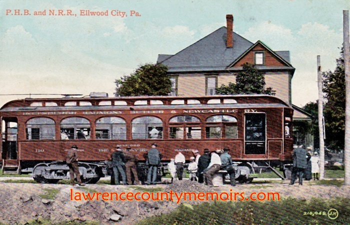
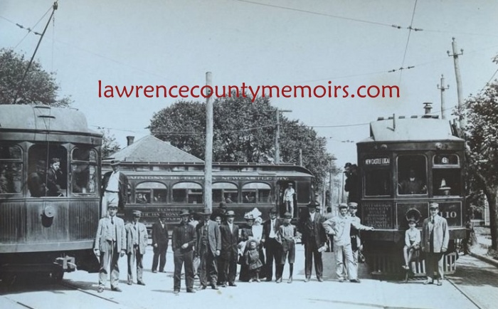
The Harmony Line, with Henry “Hardhat Harry” Etheridge of Zelienople serving as Superintendent, was opened for business in July 1908. It ran from Pittsburgh up to Evans City where it split into two sections. One line ran off to the northeast towards Butler, while the other section ran west to Ellwood City and on to New Castle on roughly what is today Route 65 (New Castle-Ellwood Road). There were over 150 stations along the way, but the trolleys would only stop at the smaller ones if someone was waiting to be picked up or wanted to stop there. There were also express cars that only stopped at select larger stations.
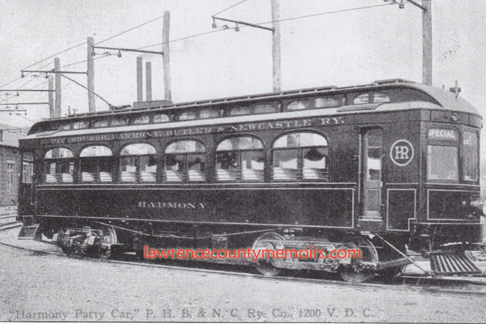
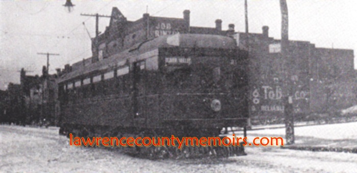
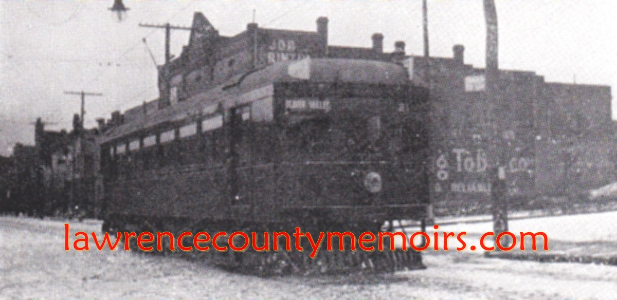
The Harmony Line featured several dozen large wooden passenger cars, which typically carried about forty people, their baggage, and limited freight. There was also a host of dedicated freight cars that were often used by farmers to carry their crops and livestock to the cities for sale. Unlike the light rails or subways with multiple cars that most people may be familiar with today, the Harmony Line ran single cars along its tracks. The line also added an elegant party car, complete with a movie projector, which could be rented for parties and special occasions for the day.
The line entered New Castle just east of Cascade Park, where it had a stop. It then continued up along Stanton Avenue-Paul Street-Butler Avenue, crossed over the New Castle-Ellwood Road (Route 65) to join Taylor Street, curved up Shadyside Avenue, and stopped at Harmony terminal at the intersection of Kurtz/County Line/Produce Streets – next to the Union Depot.
The New Castle News of Thursday, June 25, 1908, reported, “At the Pittsburg street terminal of the Pittsburg, Harmony, Butler and New Castle street railway, work has been rushed rapidly during the past week and the big building is now almost ready for the entrance of cars. In the front part of the room a baggage room with glass windows, has been constructed in front of which is the waiting room. The cars will enter the building from the rear and run up to Pittsburg street. The company has had many troubles of various kinds during the past few weeks which have delayed work to such an extent that. It may not be complete until July 10.”
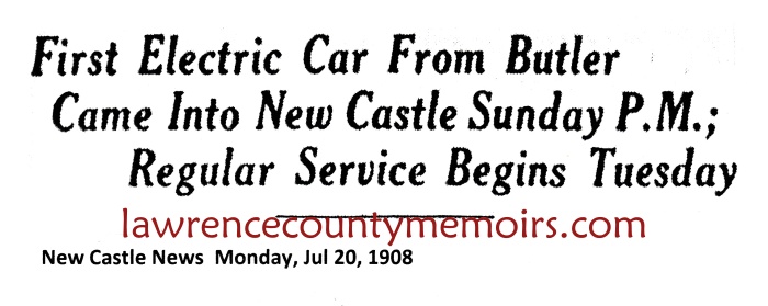
The first Harmony car, occupied by Boggs and other dignitaries, arrived at the New Castle terminal on Sunday, July 19, 1908. The New Castle News of Friday, July 24, 1908, had this to say, “New Castle people were pleased with the prospect of such a line, especially because it gives close and quick and hourly communication between New Castle and Ellwood City. They were pleased because the thing had come uninvited and would greatly develop an inaccessible section of the county. An official of the line in discussing the feature Thursday, stated that Mr. Boggs, the senior member of the firm of Boggs & Buhl of Allegheny, who is president of The Harmony Line, had never been in New Castle until after this road was started. He decided on New Castle as a terminal point because there was a good prospect of business. No New Castle money was needed and none was asked.”
The article went on to mention the facilities located at Harmony Junction with, “One immense power plant furnishes all the electricity used over the entire system between Pittsburg and New Castle. This power plant is located a few minutes’ ride beyond Harmony. Two great buildings there are the headquarters of the company. The largest, of these buildings is the power plant and the next largest is the car barn and offices. Two sub-stations, or transforming stations, are located on the line. One sub-station is four miles outside of New Castle, and the other is four miles outside of Allegheny.”
A few years later, in December 1913, a separate entity known as the Harmony Electric Company was formed. The new company immediately “leased” the power plant and transmission lines of the Harmony Line, and began supplying electric power to the Harmony Line and to several local communities. The Harmony Electric Company was just one of many electric companies that grew out of the power plants built for the various streetcar lines.
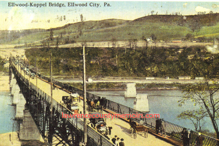
By 1911 Boggs envisioned connecting the Harmony Line from Ellwood City to an existing streetcar system in Beaver Falls. As they lobbied for the streetcar franchise from the Ellwood City council Boggs and the Harmony Line came into bitter conflict with other interests, including one led by Ellwood City founder Henry W. Hartman, with similar designs.
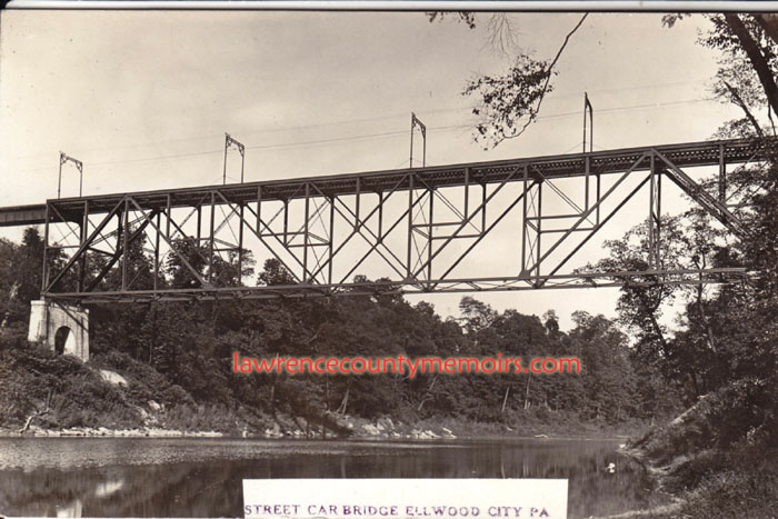
The Harmony Line, backed by its wealth and political clout, won out and commenced construction of the 6.3-mile extension of the line from Ellwood City via Koppel to Beaver Falls in the fall of 1912. This proved to be an extremely difficult endeavor and was not finally completed until early 1915. For this extension they considered purchasing the older (and recently replaced) Pennsylvania & Lake Erie Railroad (P&LE) bridge over the Beaver River, but decided to build a completely new bridge. The Koppel Bridge, carrying the trolley line and vehicle and pedestrian traffic (with a toll) over the Beaver River along modern-day PA-351, was completed in November 1914 and officially opened to the public on January 1, 1915. This line had stops at such stations as Park Gate, Hoytdale, Koppel, Homewood, and ended at the Harmony stop in the Morado section of northern Beaver Falls.
In 1917 the Harmony Line purchased the floundering Pittsburgh and Butler Street Railway, which operated a trolley between Pittsburgh and Butler (roughly paralleling modern-day Route 8) and was popularly known as the Butler Short Line. The thirty-six-mile railway was soon incorporated into the operations of (but remained legally separate from) the Harmony Line. A new section of track connected the existing Harmony Line station at Evans City with Butler was also constructed. The longer cars of the former Butler Line had some compatibility issues with the Harmony tracks and were eventually replaced.
The Harmony Line, now encompassing about 110 miles of track, made day trips around the western Pennsylvania region very feasible as its cars zipped along at speeds up to sixty-miles-an-hour. Travelers could also transfer to other urban street car systems in New Castle, Beaver Falls, and Pittsburgh to continue their journeys. From New Castle one easily transfer over to Youngstown and could continue on – if one so desired – by various trolley systems all the way to Chicago. Of course that was usually done by train. The Harmony Line was quite successful but its existence was relatively short in nature.
In June 1919 the Harmony Line and the Butler Line were sold to a young attorney and civic leader from Pittsburgh named David I. McCahill Sr. (1884-1971). He had been born in Iowa, made his way to Pittsburgh as a teenager, graduated with a law degree from Drake University, taught at the University of Pittsburgh, and embarked on a prosperous legal career in the railway and electric industries. He eventually acquired control of a handful of railway, real estate, or electric companies.
The New Castle News of Friday, June 20, 1919, reported that, “David L. (sic) McCahill, prominent Pittsburgh attorney, was yesterday elected president of the Pittsburgh, Harmony, Butler and New Castle Railway company succeeding the well-known merchant R. H. Boggs and assuming the immediate direction of the business. Mr. Boggs will retire from active participation in street railway affairs, although he will continue as a member of the board of directors. With the announcement of the change in the presidency it was also announced that Mr. McCahill has acquired Mr. Boggs entire interest in the properties amounting to something in excess of $4,000,000. The companies are known as the Harmony group and include besides the railways company mentioned the Mars and Butler Railway company, the Harmony Electric company and the North Pittsburgh Realty company.”
As far as Boggs and Buhl go their days ended like this. In 1912 they sold their successful store and settled into retirement. Due to poor management the store bearing their name soon lost its luster and in a bold move they bought it back in 1915. Boggs, the senior partner who was married to Buhl’s sister Marie, died at the age of seventy-eight in July 1922. Buhl continued with the business until he passed away at about the age of seventy-nine in June 1927. With no heirs the store went into a trusteeship. It continued its operations for many years and slowly declined as with many other urban businesses. It was closed for good in 1958 and sadly demolished two years later.
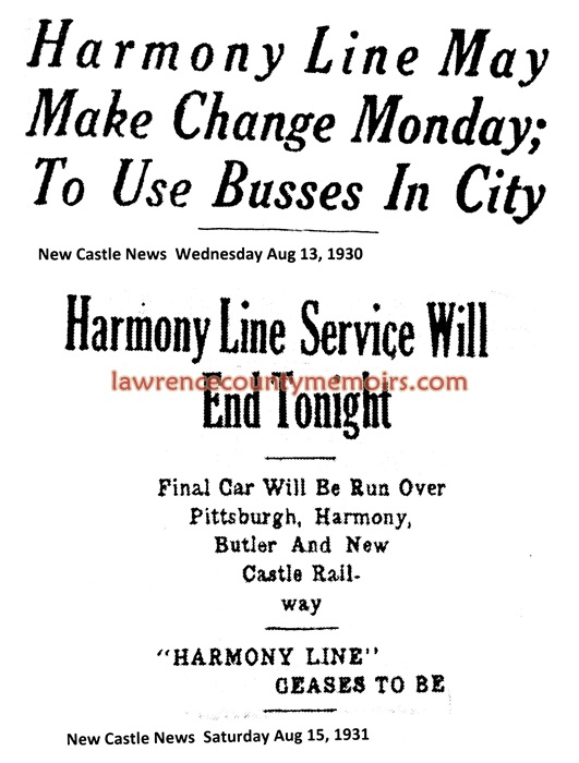
The demise of the Harmony Line began with the widespread use of the private automobile beginning in the 1920’s. In 1922 the affiliated Harmony Short Line Motor Transportation Company, utilizing trucks, was formed to haul freight along the Harmony Line. The new company also began utilizing buses in 1923 to supplement passenger service on the streetcar route in the Beaver Falls area. In June 1925 regular bus service was instituted between the New Castle terminal and Butler, a route where no direct streetcar route was ever established. By 1929 it was evident that the streetcars of the Harmony Line would soon be phased out and replaced by a more economical bus service. McCahill, losing money, had sold the Harmony Electric Company to the Pennsylvania Power Company in the fall of 1928 – and began paying for electric service for the Harmony Line.
By 1930, as the Great Depression began its stranglehold on the nation, the Harmony Line was nearing its end. In August 1930 the Harmony Line ceased sending streetcars to the terminal on East Washington Street (Pittsburg Street) in New Castle and began stopping at the station near Cascade Park. In early April 1931, despite various cost-cutting changes, the Harmony Line went into receivership due to heavy financial losses.
A legal battle ensued in Pittsburgh after the receiver filed an application to discontinue streetcar service along the entire line. The New Castle News of Thursday, June 4, 1931, reported, “Residents of Ellwood City, Evans City, Bradford Woods, and numerous points along the Ellwood City to East New Castle and the Ellwood City to Beaver Falls branches of the Pittsburgh, Harmony and New Castle Railway today took up the legal cudgel to prevent abandonment of the line sections as requested of Federal Court by Maurice R. Scharff, receiver.” Meanwhile, the streetcar routes between Ellwood City-New Castle and Ellwood City-Beaver Falls were soon switched to bus service.
The courtroom fight dragged on through the summer, but the Harmony Line was finally authorized to cease all operations. The New Castle News of Saturday, August 15, 1931, reported, “At midnight tonight the last car will run over the tracks of the Pittsburgh, Harmony, Butler and New Castle railway as the “Harmony Line” will cease operations under an order granted by Judge F. P. Schoonmaker in federal court on the request of Maurice Scharff, receiver, because of operating losses… The line to be abandoned tonight extended from Pittsburgh to Butler and Pittsburgh to Ellwood City, by way of Evans City.” Bus service was soon instituted along most of the former Harmony Line routes.
After the final closure in August 1931 the receiver began proceedings to dismantle and sale off the rails and equipment associated with the Harmony Line. The New Castle News of Saturday, October 10, 1931, reported, “Federal Judge F. P. Schoonmaker today signed a confirmation order for the sale of the equipment of the Pittsburgh, Harmony, Butler and New Castle Railways company and the Pittsburgh, Mars, Butler Railways company, excepting rails, to J. P. McCann, president of the United Mine and Metals company, for $65,000… The equipment will be scrapped.”
Apparently there were some delays in the liquidation as the New Castle News of Saturday, June 15, 1932, reported, “Modification of court orders directing the sale of the material equipment of the Pittsburgh, Harmony, Butler and New Castle Railway company and the Pittsburgh, Mars and Butler Railway Company, was granted today in federal court upon joint petitions filed by Ralph M. Morganstern. The court granted a time extension from August 18, 1932 to January 18, 1933, after Maurice R. Scharff, receiver for the defunct companies, had given his consent. Because of the condition of the market for scrap iron, Morganstern stated it would be impossible to dispose of the $100,000.00 worth of track, track equipment and bridges by August 18, the original date.” The majority of the old streetcars were scrapped and the car barn and maintenance facility at Harmony Junction was demolished a few years later.
David McCahill continued to operate the bus service of the Harmony Short Line for many years. A decline in bus ridership during the 1950’s saw it cease operations by April 1, 1961. Most of the company’s equipment and routes were swallowed up by other transportation companies, including the Grove City Bus Company.
Despite the passage of time some evidence remains of the old Harmony Short Line. A few of the former station buildings still stand such as the ones at Evans City, Wexford, and Koppel. Several streets are still named for stations in Shenango Township, including Rose Stop Road and Shenango Stop Road. The original Koppel Bridge built by the Harmony Line, though greatly refurbished, was sold to the state of Pennsylvania. The span operated as a toll bridge until 1957 and is still in use on Route 351 today. The piers of the old Harmony trestle near Cascade Park are still standing and located beside Cass Street. Many of the track right-of-ways can still clearly be distinguished on satellite maps on the internet.
All of the streetcars were scrapped except for a single forgotten car (Car #115) that had previously broken down and was abandoned in Harmony. A former Harmony Line employee turned the car into Clarke’s Diner, a business that was expanded and changed names over the years. Eventually, in 1986, the car was donated to the Pennsylvania Trolley Museum in Washington, Pennsylvania, which put in on display at its facility. The heyday of the Harmony Line was short-lived, but was remembered fondly for many years by its former patrons.
In 1906 work commenced on the laying of track and the building of bridges for the new Harmony Line. To read a few articles on that progress from 1906 to 1908 click on: OCT 1906 PROGRESS ARTICLE and AUG 1907 PROGRESS ARTICLE and MAR 1908 PROGRESS ARTICLE. To learn more about what the July 1908 opening of the Harmony Line meant click on: RELEVATION ARTICLE. To read about how New Castle and/or Lawrence County officials forced the Harmony Line to start stopping at all stations click on: MUST STOP ARTICLE. An unusual robbery took place near the Smiley Stop along the line in December 1909. To read about it click on: 1909 ROBBERY ARTICLE. To read a snippet about a funeral for a young man killed on the Harmony Line in February 1910 click on: BARNHART ARTICLE. Many new homes and small communities were built along the Harmony Line in the coming years. To read about two such communities click on: OWN A COUNTRY HOME AD and HARBISON LOTS AD. To read about two new steel cars added to the line in 1911 click on: NEW STEEL CARS ARTICLE and PLACED IN SERVICE ARTICLE. The cars of the Harmony Line occasionally encountered obstructions on the tracks. To read two articles about just such encounters click on: COW HIT ARTICLE and BOULDER ON TRACK ARTICLE. The Harmony Line, as with any railway, occasionally faced lawsuits from passengers, pedestrians, and property owners. To read an article about the line settling lawsuits in October 1911 with two women from Zelienople click on: LAWSUITS SETTLED ARTICLE. To read a front page article about a major wreck at the Hazel Dell stop in April 1912 click on: SMASHUP ARTICLE. In about 1912 the railway made plans to expand from Ellwood City down to Beaver Falls. To read about some preliminary work being performed by laying track under “the subway” in Ellwood City click on: TRACK DOWN ARTICLE. In October 1913 serious work was started on the Ellwood City-Beaver Falls extension of the Harmony Line. To learn more about it click on: WORK TO START ARTICLE. To read more the difficulty in building the new Ellwood-Koppel Bridge in January 1914 click on: QUICKSAND ARTICLE. To read the case of Rosa Scott, who was suing the line in January 1915, click on: ROSA SCOTT ARTICLE. To read a glowing editorial about the Harmony Line in May 1915 click on: HAIL THE HARMONY EDITORIAL. To read a January 1916 article about a Harmony car that nearly fell over the side of the Morado Bridge (the same one that young Ray Robinson, aka The Green Man, was shocked on just over three years later) click on: MORADO BRIDGE MISHAP ARTICLE. To read about a major accident involving the Harmony Line that occured at the North Sewickley Stop in June 1916 click on: NORTH SEWICKLEY ACCIDENT ARTICLE. To read about the death of two more injured victims a week later click on: ANOTHER DEATH ARTICLE and FOURTH DEATH ARTICLE. To read three short follow-up articles about the victims – especially Chris Haswell – from July 1916 click on: FOLLOWUP ARTICLES. In May 1917 the Harmony Line purchased the floundering Butler Short Line. To read more about that acquisition click on: BUTLER SHORT LINE ARTICLE. To learn about a Harmony motorman injured during a mishap at Morado Park in July 1918 click on: MORADA PARK MISHAP ARTICLE.
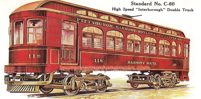 A typical maroon-colored passenger car of the Harmony Line. This particular car, built in 1914, had seats for forty-six people and was just over forty-seven feet in length. |
 |
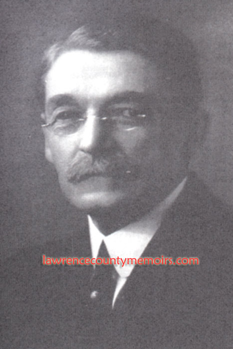 Russell H. Boggs was the driving force behind the creation of the Harmony Line and served as President from 1908 until 1919. | 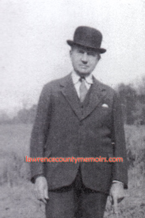 Harry “Hardhat Harry” Etheridge served as Superintendent of the Harmony Line during its entire existence from 1908 until 1931. | 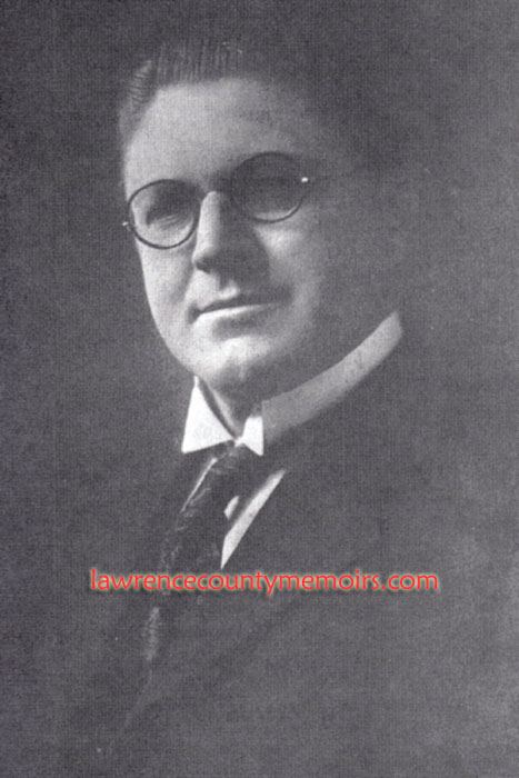 David McCahill Sr., a Pittsburgh area attorney, businessman, and civic leader, bought the Harmony Line in 1919. (c1925) |
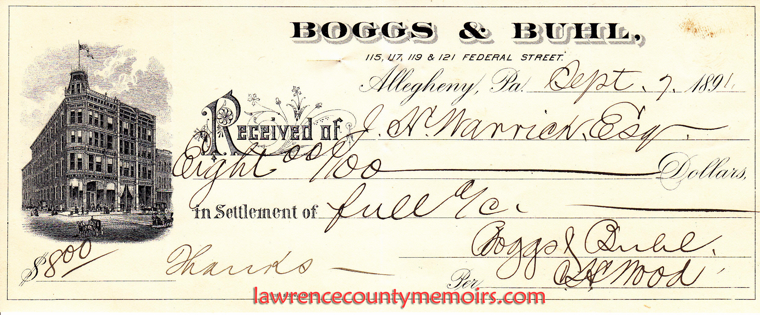
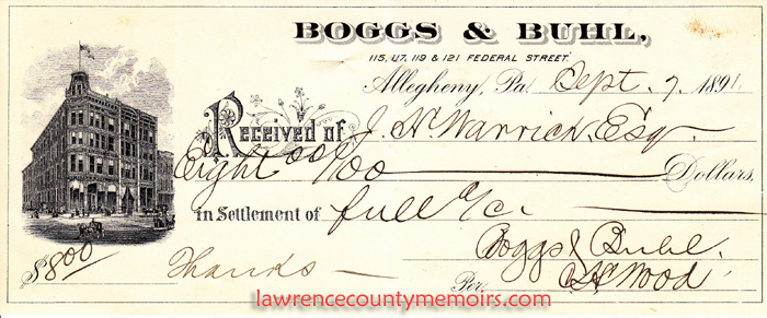 A receipt from September 1891 from the Boggs & Buhl Department Store in Allegheny City (now Pittsburgh) PA. Store co-owner Russell Boggs later founded the Harmony Streetcar Line to essentially help reach lucrative customers to the north of the city. Full Size |
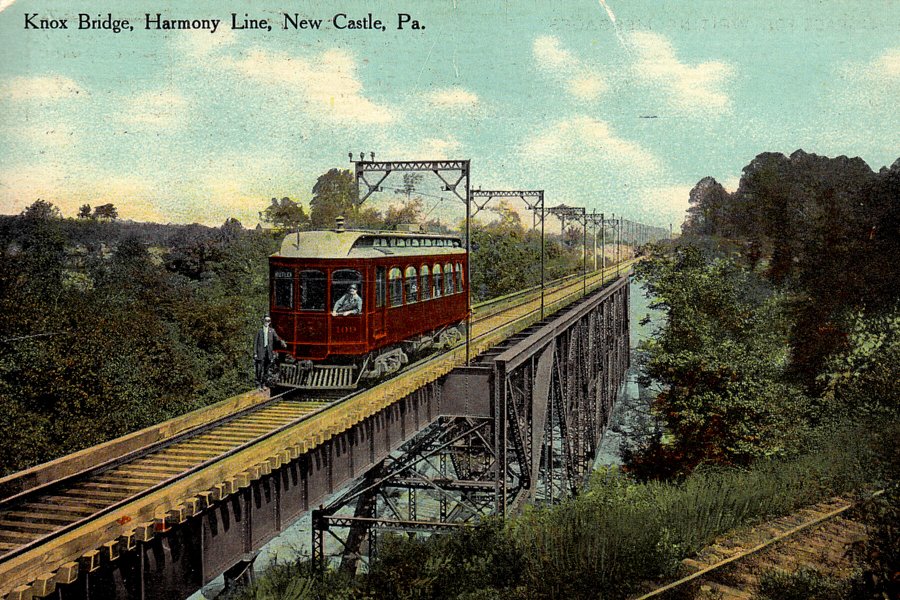 A Harmony Line car crosses the Knox Bridge across the Connoquenessing River in Ellwood City. | 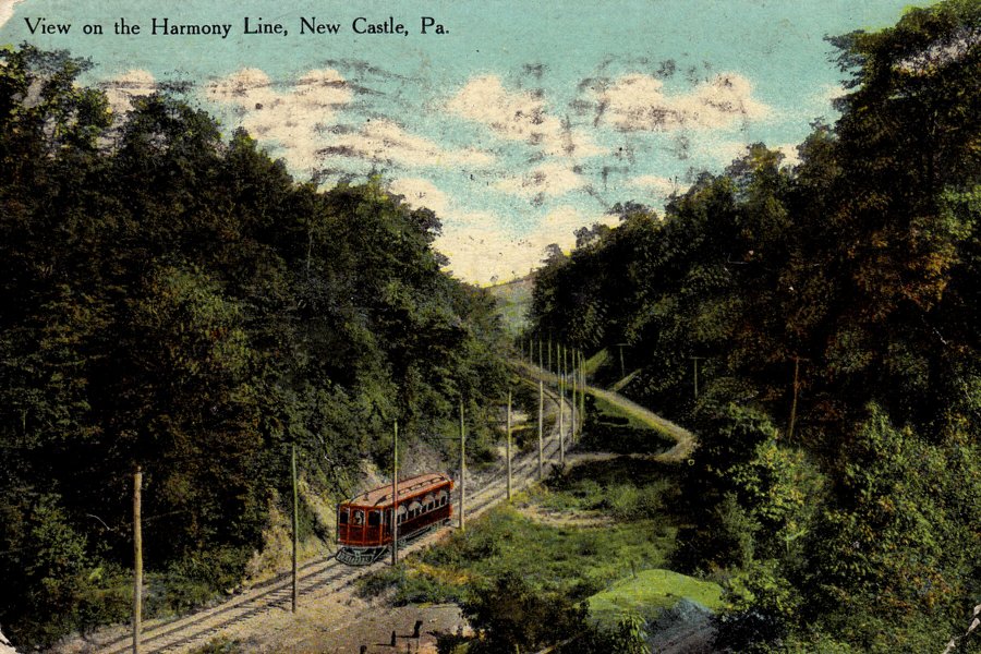 A Harmony cars passes alongside Hollow Road near the Marquis Stop in Shenango Township. |
 The Harmony Line had a relatively short existence, but provided valuable transportation to the residents of Lawrence County in the early part of twentieth century. | 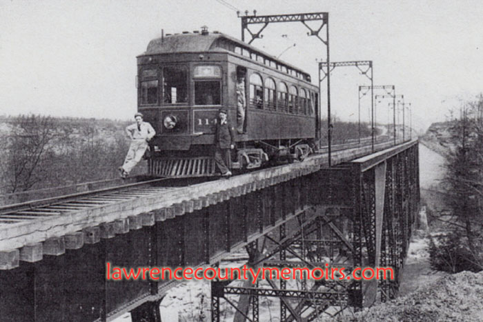 Harmony car operators pose on the Knox Bridge. c1920. |
 A Harmony car sits near the station in Ellwood City. (c1911) Full Size |
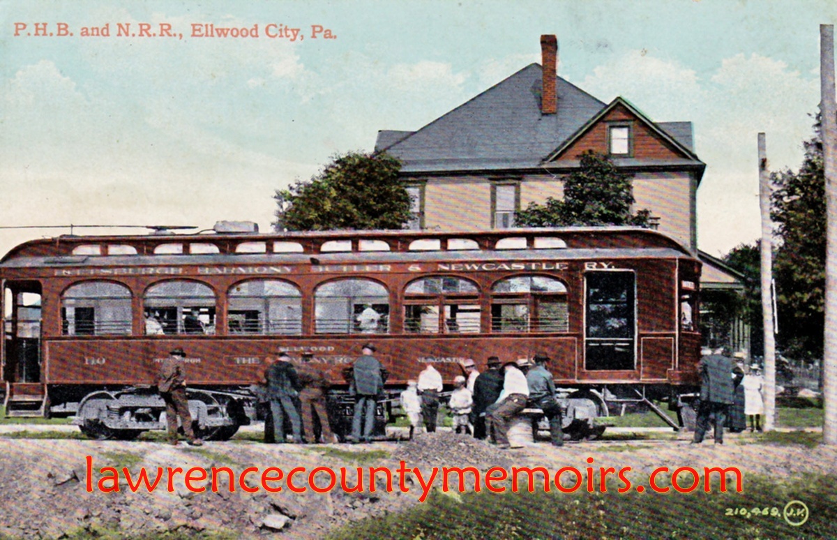
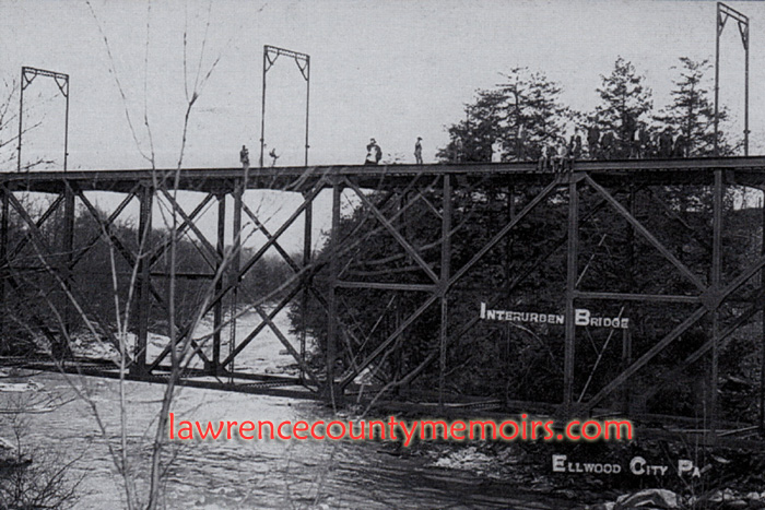 The Knox or Interurban Bridge that carried the Harmony Line over the Connoquenessing Creek, situated just north of the P&W/B&O Railroad Bridge at Frisco. (c1910) |  Another old postcard showing the Knox or Interurban Bridge. (c1910) |
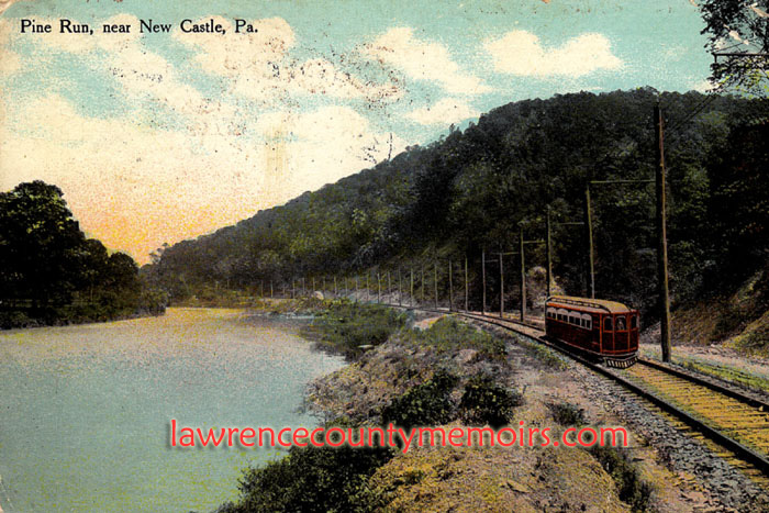
 A postcard showing the specially designed party car of the Harmony Line, which could be rented for outings while traveling the rails. | 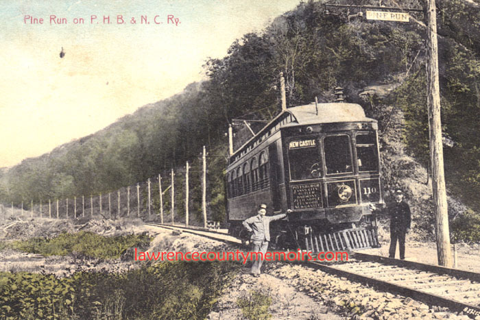 A postcard showing car #110 stopped near Pine Run. Postmarked Oct 19, 1910. |
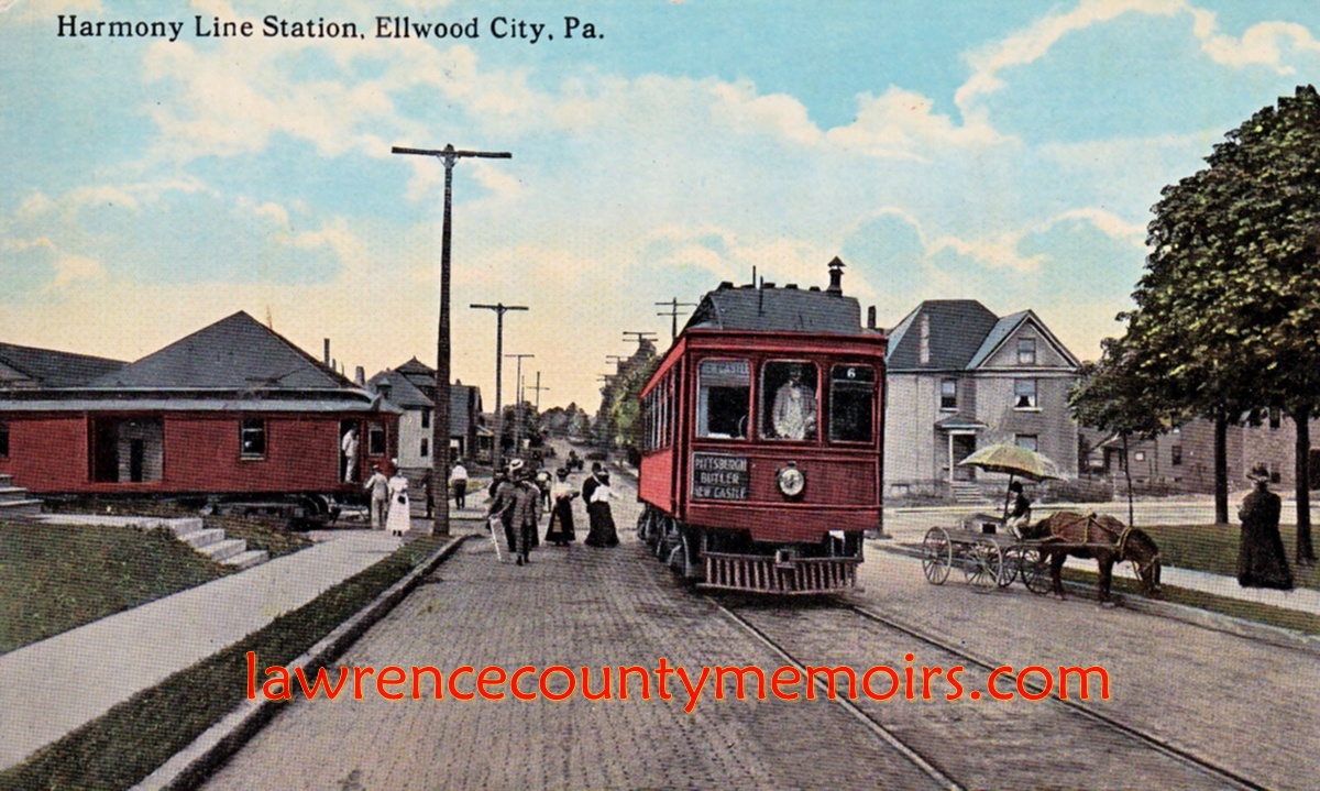
 Two Harmony streetcars at the station in Ellwood City, located just behind the car on left on photo. The streetcar in middle of photo is about to head east on Spring Avenue. On the right of the photo is the rectory for St. Agatha’s Catholic Church. (c1910) Full Size |
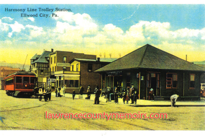 The Harmony Line heading north on 5th Street about to stop at the Harmony passenger station in Ellwood City c1915. This station sat on the corner of 5th Street and Spring Avenue. I believe at least part of it still exists as the Ellwood Station shop across from St. Agatha’s Catholic Church. The Park Hotel is visible just to the right of the Harmony car and ‘the subway’ is slightly visible behind the car. | 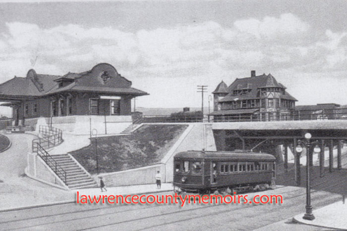 The Harmony Line car travels under “the subway” and south on 5th Street while about to pass Union Station in Ellwood City. Union Station served both the P&LE and B&O railroad lines. The Park Hotel is visible behind the subway and the Harmony station would be just up the street. |
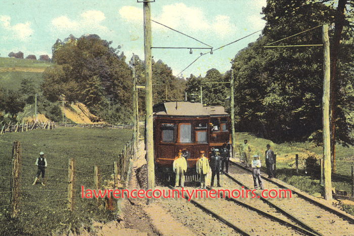 The crews of two Harmony cars pose for a photograph at the Big Springs siding (notice the dual track) just near the Marquis Stop in Shenango Township. This location is west of Route 65 right near where Workman Road meets Hollow Road today. | 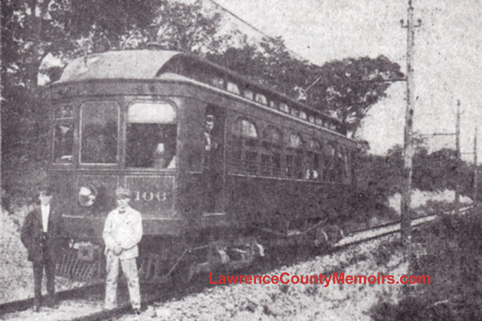 A photo showing the No. 106 car stopped near Ellwood City. In front of the car is the conductor, who managed from inside the cabin, and the motorman, who actually operated the car from the front compartment. Notice the lone track which the cars ran along at many stretches. |
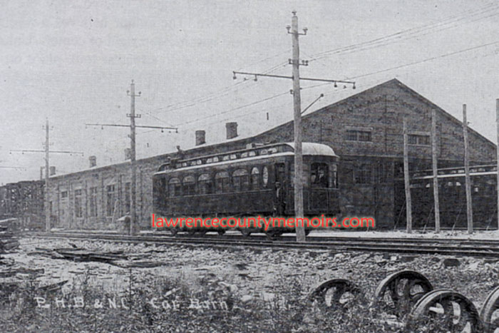 The Harmony Car passes the large Car Barn facility, constructed in 1908 and located in Harmony Junction. This structure was torn down in the mid-1930's. | 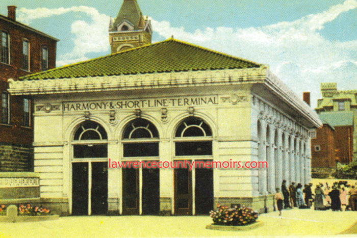 One of the nicest passenger stations on the Harmony Line & Butler Short Line, was this one built in 1921 and located on Cunningham Street in Butler. It later served as a bus terminal and was razed in the 1970's. |
 A Harmony car chugs along Lawrence Avenue in Ellwood City during late 1914. Full Size |
 The Grim Bridge, sometimes spelled as Grimm, carried the Harmony line across the Connoquenessing Creek and into Ewing Park. Photo c1910. | 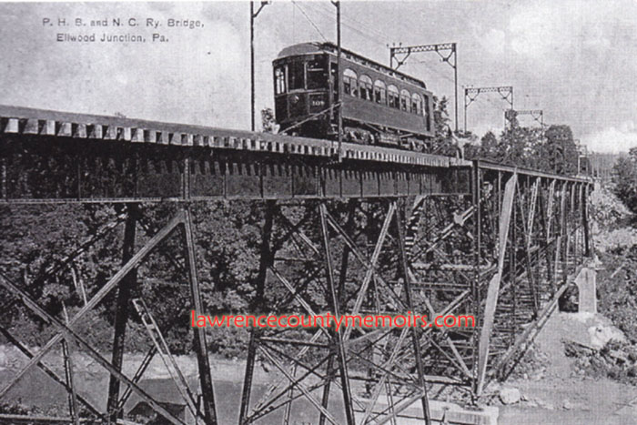 A Harmony car crosses the Grim (or Grimm) Bridge, which spans the Connoquenessing Creek and continues into modern-day Ewing Park. |
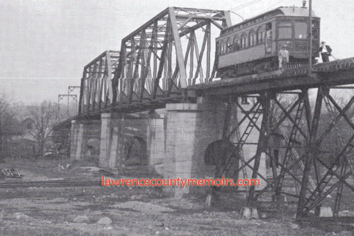 A Harmony car sits on the long trestle near Cascade Park in New Castle. The trestle carried the line over the tracks of the Buffalo, Rochester, and Pittsburgh Railroad (BRP) and the waters of Big Run. The bridge is long gone but the piers are still standing near Cass Street and behind the Auto Zone. (c1915) |
 In early 1915 the Harmony Line opened this bridge across the Beaver River connecting Ellwood City to Koppel. The structure had a single track for the Harmony cars but also functioned as a toll bridge for vehicles and pedestrians. To the right can be seen the two piers of the abandoned Hartman Bridge endeavor. (c1915) |
 |
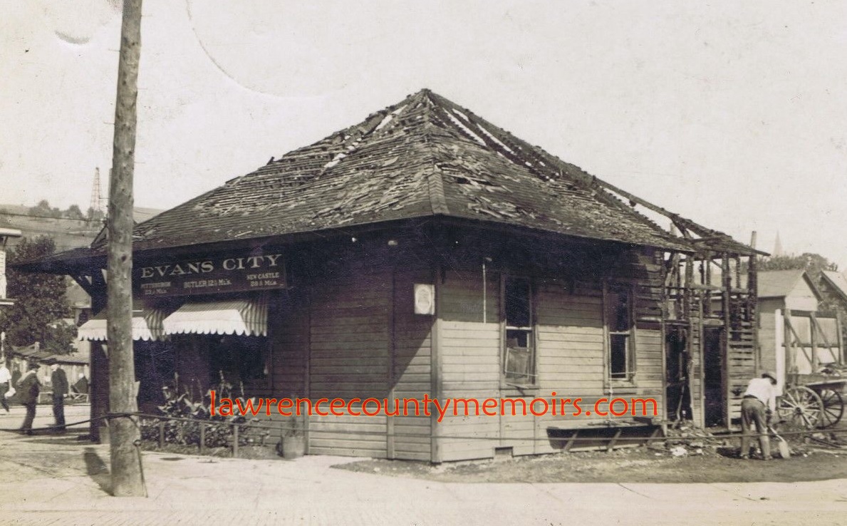
 The Harmony Line station in Evans City, where the line split in two and headed northeast towards Ellwood-New Castle or northeast towards Butler. (c1910) |
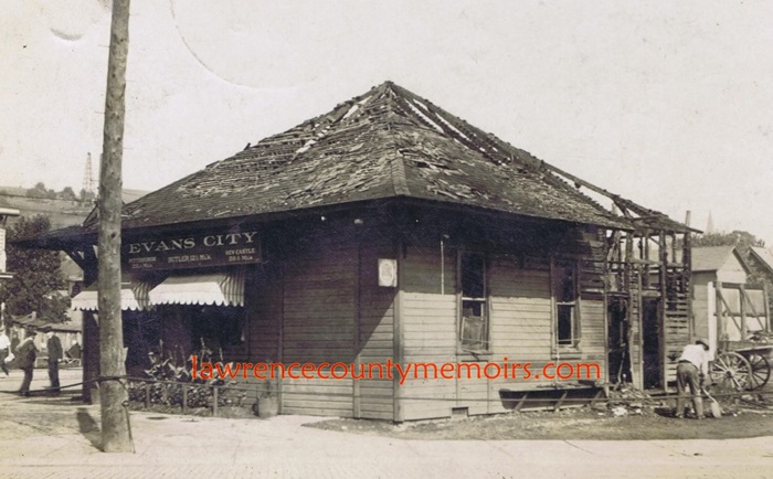 The former Harmony Line station in Evans City, at the intersection of Jefferson and South Washington Streets, sat abandoned for many years. It later renovated and is still standing today. (c1940) Full Size |
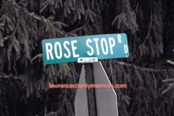 Several streets along Route 65 north of Ellwood City are still named in recognition of former stops along the Harmony Line. (Jul 2011) | 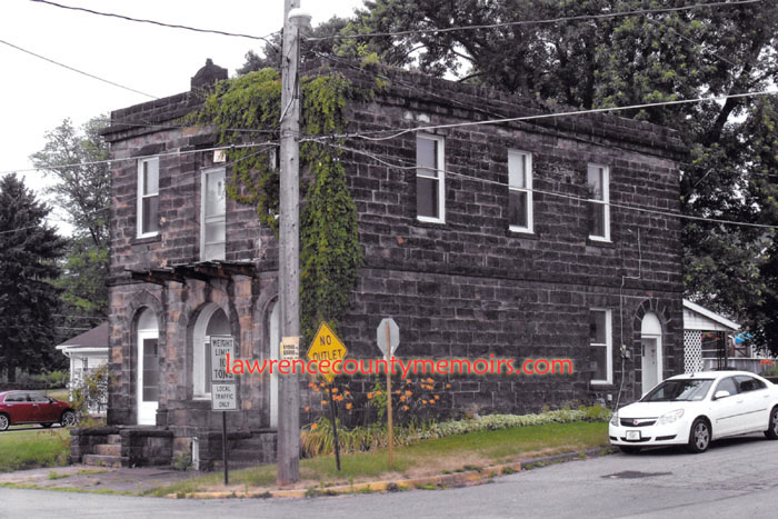 The former Harmony Line substation – also serving as a freight and passenger station – on 5th Avenue (and Ida Street) in Koppel. This stone building was constructed in 1913 for the Clydesdale Stone Company but soon purchased by the Harmony Line. Today it serves as a small apartment or rental property. (Jul 2011) |
 Modern-day view of photo #5 above. The Harmony passenger station that once sat at the corner of 5th Street and Spring Avenue in Ellwood City is long gone and is now a parking lot. I believe the L-shaped building in the back (Carla’s Diner – formerly Krestal’s donut shop and then Ellwood Station donut shop) served as a freight station for the Harmony Line. (Feb 2011) | 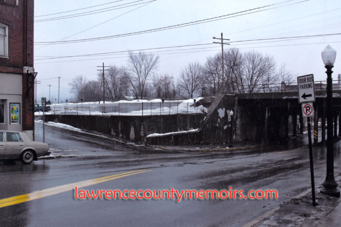 Modern-day view of photo #6 above. The subway is still in use but the old Union Station passenger station was torn down in the mid-1950’s. The Park Hotel is also long gone. (Feb 2011) |
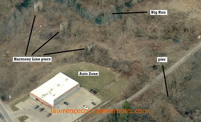 This aerial photo reveals the former location of the trestle that once carried the Harmony Line over the tracks of the BRP and the waters of Big Run. The stone piers are located behind the Auto Zone on East Washington Street near Cascade Park. (c2012) |
Comments
K.O.Prax #
Hello,
Is this part of the line that is now know as Stavich bicycle trail? Thanks for info.
Jeff Bales (editor) #
EDITOR’S NOTE – The answer is actually no, but that is an excellent question. The Savich Bike Trail is actually built on the old railbed of another interurban trolley line known as the Penn-Ohio Electric System – which generally connected New Castle to Youngstown. That line was a merger of several existing lines dating back to 1893, that became the combined Mahoning & Shenango Railway and Light Company in 1905 and renamed Penn-Ohio in 1920. The Penn-Ohio and Harmony lines would have only crossed paths in the Cascade Park area. The Penn-Ohio ended service in 1933 and the Savich Bike Trail was constructed fifty years later in 1983. Hope that answers your question.
Jeff Bales (editor) #
EDITOR’S NOTE – Excuse me its the Stavich Bike Trail. It’s named after the Stavich family, a main contributer/donator to the cost and construction of the trail.
Joy Foley #
I have been doing research to learn about a Harmony Shortline accident involving my great-grandfater, Mr. Hall and his oldest son. Do you happen to know anything about that accident or can you possibly direct me to a newspaper article? My great-grandfater survived the accident, but his son had lost both legs and died. Any help is most appreciated. Thank you and I hope to hear from you.
Jeff Bales Jr #
(EDITOR’S NOTE) Joy, the accident occurred on Friday, June 23, 1916, at the North Sewickley stop on the line just inside the Beaver County border. A north-bound passenger car – headed to Ellwood City – was stopped at the station when a north-bound Harmony freight train crashed into the rear of it. The accident occcured at 6:30am amid a heavy fog. Most of the boarding passengers were men headed to work in Ellwood City. Two men were instantly killed, ten were in serious condition, and many were slightly injured. A large group of men were standing on the rear platform of the passenger train when they suddenly heard the oncoming freight train approaching at high speed. Most jumped off the train but apparently the freight train had a large bumper of some sort that literally cut many of the men’s legs right off – while pinning them between the two trains. By all accounts it was a horrific scene. 19-year-old Richard Hall was among those and had both legs severed above the ankle. Most of the injured were sent to the Ellwood City Hospital for treatment. Another man died on June 24 and Richard Hall succumbed to his injuries on early Sunday, June 25. Among the ten seriously injured was a man listed as “Herman Hall” and there is a later report that mentions “Henry Hall” was injured but will survive. Do you think Herman and Henry Hall are one and the same?
Thanks. Jeff
Anthony #
In the picture of the Harmony Street Car on the bridge at Cascade Park you can see what appears to be a station towards the end of the bridge. Is that still standing today? Also, did the line extend past Cascade?Lastly, the Buffalo, Rochester and Pittsburgh line visable in the picture. Did those tracks run through Cascade Park, as well?
Jeff Bales Jr #
(EDITOR’S NOTE) Anthony, thanks for your inquiry. The station at the end of the trestle is most likely the Cascade Park stop on the Harmony Line – located just near Cass St. It is long gone. Yes, the Harmony Line continued up along Stanton Ave-Paul St-Butler Ave, crossed over 65 to join Taylor St, curved up Shadyside Ave, and stopped at the end of the New Castle extension – its station at the intersection of Kurtz/County Line/Produce Sts. In the last year of operation (1930-1931) the Harmony Line ended at Cascade Park. The Big Run Branch of the BR&P ran just south of Cascade Park and north of Lakeview Ave. It followed along the bottom of Big Run all the way to the Shenango River. The piers of the Harmony trestle in the picture you mention are still standing and located behind the Auto Zone on 65 and directly east of the Dance Pavilion in the park. Jeff
Anthony #
Thanks for the info Jeff! I currently live on Cascade St. near Robinson Lane and the Harmony Line ran through my back yard. It’s interesting to think what was there not so long ago….also was curious of the route it followed back towards Ellwood City. Thanks again!
VellaRuth Alberth #
The Harmony Line track ran through my grandparent’s farm on the Chewton Wurtemburg Road in Wayne Township, paralleling Duck Run. A bridge abutment is still there. For many years, their address was Slippery Rock Stop, Ellwood City, PA; I never could understand what that meant. Now I know that you could board the street car there.
Jeff Bales Jr. #
(EDITOR’S NOTE) Anthony, the line roughly paralleled Route 65 to the west. From the Cascade Park area the track crossed over 65, thru the area where Shenango High School and Kmart are located, headed SE across near where Gardner Stop Rd and Gardner Center Rd meet, crossed Shenango Stop Rd just west of Twins Oaks Drive, crossed Rose Stop Rd and Melody Lane, then basically followed along Hollow Rd and Joffre St to the Ewing Park – where it crossed the Connie Creek. I’ll try to post a map in the future. Hope this helps. Jeff
Jeff Bales Jr. #
(EDITOR’S NOTE) VellaRuth, you can see those streets west off of Route 65 with the name “Stop” in them such as Rose Stop Rd, Gardner Stop Rd, Smiley Stop Rd, and Shenango Stop Rd. They didn’t get their names by accident. They were all “stops” or stations on the Harmony Line at one time. Jeff
MELANIE QUINN #
Is there a map available showing the “stops” along the Ellwood to New Castle HARMONY SHORTLINE route
C B Nash #
Great work! I grew up in Lawrence County, PA and Mahoning County, OH. I am now located in SW FL.
So much history is being lost there as our economy dwindles.
I’m currently in the planning stages for my third novel,while the second is being edited. I may set a large part of the story in a fictional Western PA drown town, known as Sycamore Mills.
Keep up the good work!
CB Nash
James G Houk #
Carla’s resturant and Krestal’s donut shop. that building was once a Feed Store. I remember my Dad buying chicken feed there back in the 50’s or 60’s. May be it was Diamond Milling back then?
Clato Keith #
I am looking for a newspaper article about my aunt who was killed in a train accident at Harmony Junction in the early 1970’s.
I am sorry, I do not have much information.
thank you
Jeff Bales #
(EDITOR’S NOTE) Clato, I sent you an email a while back. I need your aunt’s name to be able to search for any information about her. Thanks. Jeff
Jeff Bales Jr. #
(EDITOR’S NOTE) Melanie, there is a map floating around on the internet of the Harmony route(s). I have a copy somewhere and I’ll try to email it to you. Jeff
Kim #
I am researching another company owned by the businessman, David I. McCahill, that was operated in Allegheny Couunty, the North Pittsburgh Realty Company. I could never find a dissolution or sale of the company, and I was curious if you knew anything more on David McCahill? I have a copy of his estate from the courthouse, but there is no mention of the company, I am presuming it was extinguished prior to his decease.
Anthony #
Did anyone take over the track right aways from the Harmony Line after they were defunct? Hard to imagine all that track would just be discarded
Mike Costello #
Hello:
Was there a line that ran along the creek where Riverside High School is now? about 1/4 of a mile below the school, there’s some old bridge abutments along the creek.
Thanks
Tim #
Kim,
In regards to your question about the track right of ways after the interurban service went out of business, I have done extensive reading and local research of the Harmony/Zelienople/Evans City areas of the PHB&NC and am fascinated on a historical level based on what I have read, and working/driving in the area on a daily basis for work, specifically the area of where the Harmony Car Barn once sat.
At least from what I have learned on the local area, the Harmony Car Barn (where the cars used to be maintained and serviced, which used to sit near the intersection of State Route 68 and Hartmann Road, just east of Zelienople and Harmony – where Berry Metal Company sits now) there was also a power generating plant that supplied electricity to the interurban line, since they ran on electricity. After the interurban service stopped and the “Short Line” became a bus company, the company that was to become Penn Power bought most if not all of the right of ways, including the power generating plant. A little known piece of historical information is that it was the PHB&NC that actually brought the first electricity service to the Zelienople/Harmony/Evans City areas, due to the electric generation plant that was located at Harmony Junction.
Knowing what to look for in the area, you can still see where the track used to lay, if it has not been developed since that time. Some of these right of ways still have telephone poles that run through what are now wooded areas, which without prior knowledge one might think “What would possibly possess the power company to run electric lines though an undeveloped stretch of wooded land”. That is because what is now grown in land, once was cleared and already held power lines from the interurban lines.
Now if I could only bottle the wealth of useless information I possess and sell it.
deb reeb #
In one of your replies above you mentioned a map of the route…can you please send me a copy? I was told that my home was a stop on the route but can’t find any confirmation other than a record book which has something like postal stamps in it….the book could have come from anywhere….I’d like to find some type of confirmation that we were truly on the route.
thanks!
Terri Ritchey Freeman #
My mother was born in Zelienople in 1928. She remembers riding the street car to Cascade Park. We lived at 1013 Willowbrook Rd. in Shenango Twp. and there was a cleared area behind the woods in our backyard that still had the old street car tracks.
Chuck Sankey #
Thanks for having the Butler Harmony Short Line Terminal picture. I remember the building used as the city bus terminal depot. Later around 1965 there was a laps in smarts and was leveled into a parking garage (Thanks urban renewal).
I was wondering if there are any maps of the original route of the rails?
Also are there pictures of the bridges around the Lindora area? The main East West route through Meridian, Pa., Highland Ave, is easily seen parallel to the street, as also visible in Highfield near Lyndora.
When I was young, at Preston Lab (Highland and S. Eberheart Rd, At the large old gates the local station stop was pulled back into the woods.
Debbie Bevis #
Hi,
My grandfather, John Clark Sergeant, was a street car conductor on the Penn-Ohio line from New Castle to Youngstown. He was a member of the Street Railway Employees (A.A.) Part of the Divison No.89(Late Turn) from the late 1890’s till his death in Jan. 1931. He and my grandmother Bertha Mae Zenesta Jenkins meet on the trolley and were married in New Castle in 1906, both coming from long-time New Castle families. I treasure the picture I have of his railway company, they were so very dedicated. Thank you for the pictures and your research of the trolley lines it has special meaning to our family.
Steve Jones #
I’ve been to Elwood City for work several times and never knew there was a trolley line there. How did it run between Elwood and Zelienople? Did it follow the modern tracks, the road, or have a separate right of way? No trace of anything on the maps.
Thanks!
Raymond Vance Olszewski #
I had two Uncles who were Harmony Short Line bus drivers in the 1950s/1960s. Is there a list anywhere of HSL employees that I can access online? Thanks, Great article
Dee #
Does anyone know where the Building Springs on the Harmony line would have been? This was referenced in a newspaper article from New Castle PA dated 1910 for a family reunion.
Jennifer Jerasa #
Was this the sane street car that ran along the river in the area of Edinburg/Pulaski? There are still elevated “track marks” that run along where the railroad ran, my dad says it was street car tracks.
Heidi Meckler #
My great grandfather was a motorman possibly on the Harmony line: Rudolf Meckler maybe 1910 thru 1940? Pittsburgh Railways Co. 6th Ave PGH, ALLEGHENY,PA….
I’m looking for records and photos.
Thank -you
Donald Ajluni #
Ny great uncle, Chekri Barham, a Palestinian immigrant, was killed in 1919 while getting off a street car in Pittsburgh. My aunt told me his coat got caught in the door and he was dragged. Is there any information or record of this accident?
Donald A
Amy Downing #
Hello, I love all the detailed research you have compiled, however I am unable to find any map routes. I have been told that the trolley ran right behind our home and that our neighbors house was actually a station stop. Our homes are actually set up backwards, you enter through the front door into the kitchen. So where the trolley was in the back was actually the front door to enter the living room.
Anyway, any help with a map of Frisco would be greatly appreciated. I did really enjoy seeing the Knox pictures as my children and I visit the creek quite frequently and know where the old pillars are.
Thanks again!
Ted Hunkele Jr. #
Thanks to your website, I was able to find the approximate location of my father’s Harmony Junction Camp Cabin from your response to Kim 06/14/2013,12:30 AM. The cabin was adjacent to Connoquenessing Creek at the end of a row of one-storey cabins.
From a Google Map and if it still exists, the cabin should be located either east or west of the S.R. 68 intersection with Hartmann Road along the creek.
Thanks!
Ted Hunkele
John S. Massa #
Regarding the building you profiled above:
“The former Harmony Line substation – also serving as a freight and passenger station – on 5th Avenue (and Ida Street) in Koppel. This stone building was constructed in 1913 for the Clydesdale Stone Company but soon purchased by the Harmony Line. Today it serves as a small apartment or rental property. (Jul 2011)”
The stonework for this building was done by my father’s uncle: Samuel Massa (born 1864 in Campolattaro, Italy; came to the US in 1902). My father is Manfred Massa (born 1915 in Falls Creek, PA) son of Emilio Massa (born 1879 in Campolattaro, Italy) and Maria Libera (Fusco) Massa (born 1898 in Morcone, Italy). My father’s family lived at 351 3rd Ave, Koppel, PA.
Coincidentally, my mother (Concetta “Connie” (Botte) Massa) and her three sisters (Rita (Botte) Scopellite; Jean (Botte) Calabrese; Mary Lou (Botte) Ebersberger) lived in this same stone substation building (upstairs apartment?) as young children, with parents Sam Botte (born 1880 in Faicchio, Italy) and Theresa (DelGaudio) Botte (born 1895 in Formicola, Italy), until about 1922, when they all moved to 442 2nd Ave, Koppel, PA. (They had three additional children: Fred Botte (former Mayor of Koppel); Paul Botte; Joseph Botte)
John S. Massa
jsmassa@yahoo.com
James Love #
I’m vary curious on trying to find all the lines of the PHB&NC as the whole are between the Ohio River over to Allegheny River has been dumped for most part by Intercity Lines and whats left is so badly operated, funded what’s left of Pennsylvania Class 2 PAT, and the smaller PA Classed 3,4 & 5 transit systems are poorly operated and can’t connect to give decent service to all areas that need services reinstated or improved. It get far worse when the volunteers on transit act like railroad, canals that built our Nation are stated to the volunteers that they can’t be used today to better transit today. When I left what’s now Glade Run in July 1981 I know full well whats out there as the volunteers and leaders from Federal down to State County and local offices act as if there’s not enough people to put services in these area. All along many of the HSL’s lines are growing and need to be reconnected. After getting into Housing from being on streets for 32 years I’m now trying to focus on learning each line of HSL’s property and to walk them or walk along them. On May 29,2018 I bused to Beaver Falls and walked to North Country Trail before getting a ride to New Castle Wal-Mart to meet Foster Brother that lives in Edinburg PA now. When I got home I’ve been pulling articles from this page of history to slowly dig up more information. A man through the Facebook Page of the Cranberry Historic Page put a map up that shows how the HSL’s line has been through many of the rich’s scams that took over with their National City Lines and the Ambridge Pipeline type map that is built on HSL’s Pittsbrugh-Glade Mill’s area. Adding that I’m under the understanding that HSL had plans to expand into Ohio. Was there plans to push the HSL lines over here to Allegheny River? How much of a impact did National City Lines deeply have with creating the larger than understood disconnect between Erie PA to Pittsburgh along our major highways today from North to South and East to West? I don’t own a vehicle at this time but would be willing to bus to meet talk to learn and even pay for fuel to have others ride me show me where these lines are indeed located in each area. Thanks James Love (412) 660-0998 trailuser15065@yahoo.com
Lori #
I am searching for any information regarding The Short Line that ran through Butler, Pa. The trolley line ran through my parents property on Kriess Road, Renfrew. My father has always said that there was a stop across the Street but I am unable to find any information or photos on that stop on what is now Kriess Road. Any info would be great, thanks!
William Main #
Thank you for the website! For the first time I understand those weird road names like Rose Stop, Shenango Stop, etc! I lived at 707 Harmony Baptist Road in Shenango Township in the 1980s. The Harmony line right of way went thru my yard along Station road. In the mid 1980s some people used metal detectors to look thru 714 Harmony Baptist because they said there once was a stop, station or store in the Northwest corner if Station road continued into that property. I always heard Station road got its name this way and not from the fire station that was there until the mid 1980s.
Amy Downing #
My backyard ends right at River Road in Frisco. Across the road is the Connoquenessing Creek. We have been down there several times to swim, fish, and just explore. There are several stone pillars along that area of the creek. We were also told that the alley/paper street behind our house was once part of the trolley line. When we were remodeling our house we actually found an old trolley ticket. Any chance you have a map or pictures of where the trolley went through Frisco? My old neighbor, since moved, had told me that their house was once a station. It’s actually the first house once you cross the creek. I would love to find out more info if you have any or could point me in the right direction.
Thanks!
James Gillespie #
The 1921 Sanborn Fire Maps of Ellwood City show where the track ran in 1921, which from the North came from Duck Run to Joffre to Railroad and from the Ellwood Junction west down Fountain to 5th and then down Lawrence Ave to Park Gate….
Comment